Menu
Log in


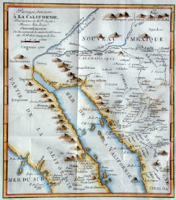
Passage by land to California. Discovered by Father Eusebius Francis Kino, a Jesuit, between the years 1698 & 1701 containing likewise the New Missions of the Jesuits.


Kino's map is a compendium of information. The configurations and latitudes of the major geographical features are essentially correct. Missions founded by Jesuits and Kino are located. The names of the Indian peoples are given and a large number of Indian villages are located. San Xavier Del Bac (S. Francois Xavier du Bac on the map) was a large village and in time became the site of the famous mission. San Cosme del Tucson  (S. Cosine on the map) gave its name to the modern city of Tucson.

Eusebio Francisco Kino was an educated Italian Tyrolese who became a Jesuit priest after university study under several cartographers. Arriving in Mexico in 1683, Kino joined a mission-establishing voyage to Baja California. Early missions proved unsuc­cessful but Kino crossed the peninsula along the river St. Thomas, shown on the map, to the Pacific. Here he found cold water blue abalone proving to be of later significance. Kino was then assigned to Sonora in northwest Mexico. There he established missions as far north as present-day Arizona.
At the time of Kino's assignment to Sonora, he was a firm believer in the insularity of California and had drawn maps showing this. In 1699, while at the Gila River, the natives gave him blue abalone shells that could have come only from the Pacific. This suggested to him that California was not an island. His later expeditions sought to confirm this. In 1701, at the confluence of the Gila and Colorado Rivers, he viewed the continuous mountains to the west and convinced himself that California was attached to the mainland.

In 1701 Kino sent a report to Mexico City including a map of his observations. A copy found its way to Europe where it was published in Paris in 1705.

Kino was highly respected by the native peoples he befriended. His bones are still venerated in the town of Magdelena, Sonora, Mexico.

Bill Warren / Dora Beale Polk

Passage par terre A la Californie Decouvert par le Rev. Pere  Eusebe-Francois Kino Jesuite depuis 1698 jusqu'a 1701 ou l'on voit encore les Nouvelles Missions des PP de la Compage. de Jesus [Engraved, 23.5 x 20.8 cm. Published in Lettres Edifiantes et Curieuses, V Recueil. A Paris, 1705 and Memoires de Trevotix, Paris, 1705.

Father Eusebio Kino's of the Gulf of California, parts of Sonora and the Colorado and Gila rivers was drawn from observations made by him in the years 1698 to 1701. The observation that the Gulf of California terminated at the mouth of the Colorado River and that California was attached to the mainland ended the myth of "California as an Island" (maps 2,3).  Image courtesy of a Society member.

From Warren Heckrotte (Ed.) & Julie Sweekind (Ass't Ed.), California 49 [/] Forty-nine maps of California from the sixteenth century to the present, California Map Society, Occasional Paper No. 6,with The Book Club of California, San Francisco, CA, 1999.


The CALIFORNIA MAP SOCIETY is a not-for-profit California corporation and a 501(c)(4) corporation under federal law.  Copyright 2001-2021.  To contact webmaster, click here. 
Powered by Wild Apricot Membership Software