|
|

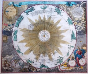
Johann Doppelmayr (1677-1750) was a Professor of Mathematics at the Aegidien Gymnasium in Nuremberg. He wrote on a number of topics, including astronomy, geography, cartography, spherical trigonometry, and scientific instruments, and he collaborated in the production of terrestrial and celestial globes. He was a member of the Royal Society of London and the Berlin and St. Petersburg Academies of Sciences. In the early 1700s, Doppelmayr prepared a number of astronomical and cosmological plates that appeared in several works by cartographer Johann Baptist Homann (1664-1724), who founded a famous cartographic publishing firm that continued through his heirs until 1848. In 1742, these plates were collected and issued as the Atlas Novus Coelestis in quo Mundus Spectabilis…. This atlas had a total of 30 plates, 20 that dealt with various astronomical themes (e.g., cosmological systems of Copernicus and Tycho Brahe, planetary and other bodies in the solar system), and 10 that were constellation maps showing the positions of the stars and the paths of comets. A particularly rich example from this atlas is shown in the figure, entitled "Systema Solare et Planetarium" (48.2 X 56.8 cm, 43.6 cm dia hemisphere). This beautiful plate depicts the state of astronomical knowledge in the early 1700s. In the center is a spectacular representation of the Sun-centered heliocentric world introduced by the great Polish astronomer, Nicholas Copernicus. The view here includes descriptions from the Dutch astronomer Christiaan Huygens, complete with sunburst and showing the orbits of the planets and their moons revolving concentrically around the sun. The rest of the universe is shown in the form of the twelve constellations of the zodiac. In the lower right corner below the illustration of a lunar eclipse, we see representations of three cosmological systems that are being introduced to us by Urania, the goddess of astronomy. Going left to right, we first see the system of the ancient Greek astronomer, Claudius Ptolemy, which is partially obliterated by contemporary astronomical instruments (allegorically implying that modern science has dispatched this view). In this system, the Earth is in the center, followed by the orbits of our Moon, Mercury, Venus, the Sun, Mars, Jupiter, Saturn, and the fixed stars. A hybrid system developed by the Danish astronomer Tycho Brahe is next. In this model, the Earth is in the center and is orbited by the Moon and the Sun. However, Mercury, Venus, Mars, Jupiter, and Saturn orbit the Sun, giving sol some semblance of grandeur. But the fixed stars continue to surround the central Earth. The final model is labeled sic ratione (i.e., according to reason) and is the Copernican system. This labeling and the central dominance of Copernicus' ideas in this print clearly indicate the opinions of Doppelmayr, even though alternative models are included in the corner for historical purposes. Nick Kanas The text and images of this celestial map is from Star Maps: History, Artistry, and Cartography, by Nick Kanas (Springer/Praxis, 2009 [2nd printing]). Dr. Kanas is a Professor of Psychiatry at the University of California, San Francisco, and he does NASA-funded research with astronauts working in space. He has been an amateur astronomer for over 50 years and a collector of antiquarian celestial maps and books for over 25 years. He can be reached at nick.kanas@ucsf.edu. Nick is a "star" CMS member. |