|

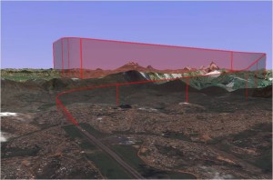
Mapping has now converged on the desktop and web. You can do-it-yourself for your own needs or just for fun. You can collaborate with others in mapping too. For now we’ll call this movement, DIY maps or mapping until the community comes up with a better name. A DIY map for planning aircraft landings. The image above depicts a simulated aircraft flight path into a third world airport. Done on a laptop computer with data freely available on the web, the flight planner was able to define a descending flight path around obstacles and terrain limitations that fit the commercial jet performance specs and flight safety rules. To do this he needed precise lat / long and elevation data, surface imagery data, his specialized flight performance software, image processing capabilities and a good laptop computer. He exported this and other images plus detailed mapping data to PowerPoint for presentation to the air traffic control authorities to plan future approaches to the airfield. All was done over a few hours of time.[/caption] DIY mapping is a technology explosion taking place as we read these pages. New products and even new concepts are being released each month. On this page we’ll try to keep abreast of events and point you to places for more answers to your questions. We’ll try to keep the view from 40,000 feet and not in the minutia. We’ll provide a few examples in our maps & stories section of Modern Mapping as good examples become available.Before we go any further you might ask how this explosion happened and why now. Here’s a thumbnail list of some of the technology convergences over the past 2 decades that are creating this explosion:
All these factors have been enough to create new industries, but the impact of these developments in this decade put a pedal to the metal for DIY mapping:
To all this add the migration of all types of data into a digital form. Put all these new capabilities in a pot, stir only briefly, and you can dish up an unlimited array of tools and applications for DIY mapping and GIS. We’ll generally focus on the free or very inexpensive DIY mapping solutions here. Keep the development factors highlighted above in mind as they define many of the dimensions to how you might do a specific DIY project. Coming soon will be separate pages with overviews and references for desktop and web-based mapping as well as types of data and where to go for sets of it. Here we’ll keep it simple and stay with web based implementations for your DIY maps.
FREE OR INEXPENSIVE WEB BASED DIY MAPPINGPossibly the first places one would think to go to for this kind of mapping are Google Maps or Google Earth. More recently Microsoft has offered a competing service, Bing Maps. All three of these offer simple user interfaces for straightforward uses but more advanced application environments for developing your own maps. There is a lot of information on the web on how t use these advanced features as well a growing number of books. Possibly the most user friendly place to start though is the National Atlas of the United States®, a website developed by 20 agencies of the US government lead by the USGS. The last national atlas in 1970 cost $100 each and only 15,000 were printed. With the new digital National Atlas you can create your own maps and with a wide range of data at the website for free. Go to http://www.nationalatlas.gov/. This site is not for road maps though; it’s for visualization a geographic data over maps, essentially a simple GIS with the data too. For maps with an emphasis on location including roads and points of interest, there are at least three that enable “collaborative” mapping – enabling (encouraging) users to input their own local data to refine the extant data portrayed in their maps. The users benefit as well as the provider. Google was able to substantially enhance its maps of India by encouraging local editing and enhancements through its Google Map Maker site (http://www.google.com/mapmaker). It is anything but intuitively obvious to use – but somehow folks have put it to use. In fact there has been sort of a WWW competition between the Google mapping community and its principal competitor, OpenStreetMap, to produce accurate maps of Haiti following the earthquake – a true need for the relief effort. OpenStreetMap which is free and “open source” can be found at:http://www.openstreetmap.org/. A new entrant in this space is WikiMapia whose stated goal is “to create and maintain a free, complete, multilingual, up-to-date map of the whole world”. Its approach is to marry the wiki technology of Wikipedia with the Google Maps sort of technology. Go to http://wikimapia.org/wiki/Main_Pagefor a start that feels a little friendlier than the other two. At this point one might ask about all the travel and route planning software that has been available for years. Good question and we’ll try to cover that as a separate page as the field is too extensive to cover in this overview. If you’re aiming at more sophisticated mapping and especially GIS projects on your own, you should consider trying ESRI’s ArcGIS Online, a free entry-level version of their product line with some free data available as well. Go to http://www.arcgisonline.com/home/ for the tutorial and account set up. Going this route may also introduce you to the breadth of professional level data available and that you may need to digest in your DIY map applications. For starters on this for US data check out geodata.gov for free stuff at http://gos2.geodata.gov/wps/portal/gos. There’s a developing field called “mashups” that are a combination of multiple sources of data into single representation – sort of a “poor man’s” GIS when it’s applied to maps. A great example of this is a mashup created from a number of historic maps of Oakland, California that are geo-referenced and “rubber sheeted” to overlay one another. One then selects the year of interest to see what was mapped at that time – and you can toggle between the years to see the development and evolution. Go to http://teczno.com/old-oakland/ and be sure to zoom in and out as much as you can. It’s a great example of marrying the old and the new well. For those who are intrigued by mapping other worlds, the USGS provides a free online mapping system for the Moon, the inner planets, and moons of Jupiter and Saturn. Go to its Map-a-Planet website athttp://www.mapaplanet.org/ to get started – and you won’t find it alien either. For the more ambitious, the PIGWAD site (http://webgis.wr.usgs.gov/index.html) noted on the GIS page can beam you up to the next level. And for the sightseers, you can always go to Google Moon, Google Mars, or Google Sky, for a gentler ride. As always, but especially here, there will be more to come. |