|
|

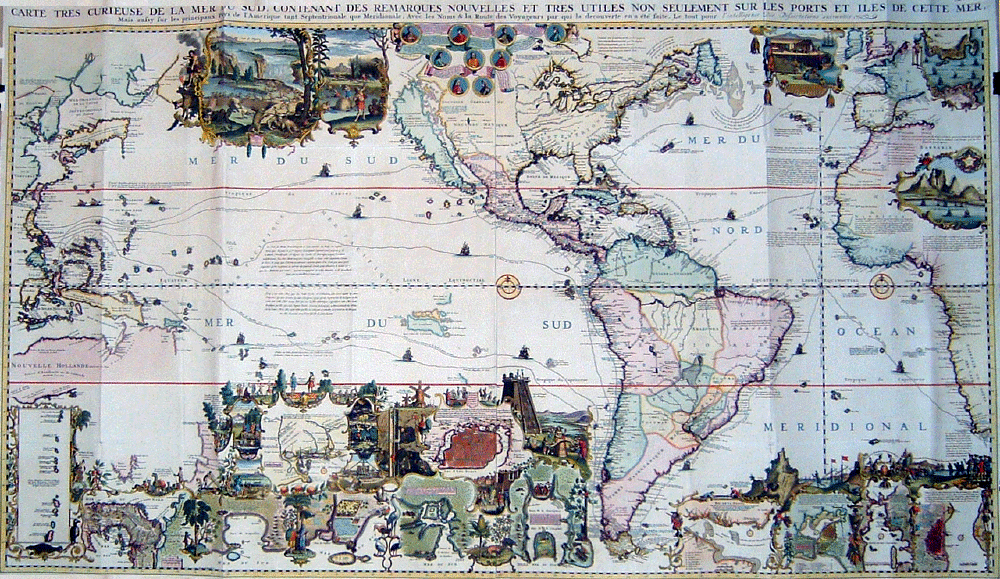 Click on link to see selected details of this map: Very Curious Map of the Southern Sea Richly decorated, finely engraved and extensively annotated, this large work is perhaps the most spectacular map of the Americas ever published. It originally appeared in 1719 in the sixth volume of Châtelain's Atlas Historique ou Nouvelle Introduction à l'histoire à la Chronologie et à la Géographe Ancienne et Moderne. (The seven volumes of this historical atlas were issued over fifteen years, from 1705 through 1720.) Although the map extends from Asia's Pacific Rim at the left to the western parts of Europe and Africa at the right, its focus is on the Americas. The map contains a plethora of geographic information. It tracks the routes of a number of great voyages, including the first encounter with the "New World" by Columbus in 1492; the somewhat later and more southerly visits by Amerigo Vespucci, after whom Waldseemuller named the hemisphere "America"; the first circumnavigation of the world by Magellan in 1520; and the first English voyage around the world in 1577-1580, during which Sir Francis Drake landed north of present day San Francisco (in what is now called Drake's Bay), claimed the territory for England, and named it New Albion. (The medallions in the top center of the map include portraits of Columbus, Vespucci, Magellan and Drake.) The map also shows some of the newer discoveries, such as the course of the Mississippi River and the correct number (five) of Great Lakes. It also perpetuates the misconception that California is an island, although it includes a notation that "moderns" believe California is really part of the mainland. The lavish illustrations and substantial commentary taught the atlas' original readers about the curious (to them) flora, fauna, peoples, activities and history of the Americas. The illustrations include the following: an intricate cartouche with two vignettes of beavers, one showing them constructing a dam and the other showing them being hunted by indigenous people; an inset of silver mining, which provided the Spaniards with great wealth; a view of Aztecs sacrificing a war captive at a pyramid; an image of sugar cane being processed; and portrayals of the indigenous opossum, muskrat and pineapple. (Close-ups of each of these illustrations are available by clicking the appropriate links around the map.) David Kalifon Carte Tres Curieuse de la Mer du Sud [engraving, 81 x 140 cm. First appeared in Châtelain's Atlas Historique ou Nouvelle Introduction à l'histoire à la Chronologie et à la Géographe Ancienne et Moderne, vol. 6, 1719.] Image courtesy of a Society member. |